7th July, 2025
Improvements to LiveOps
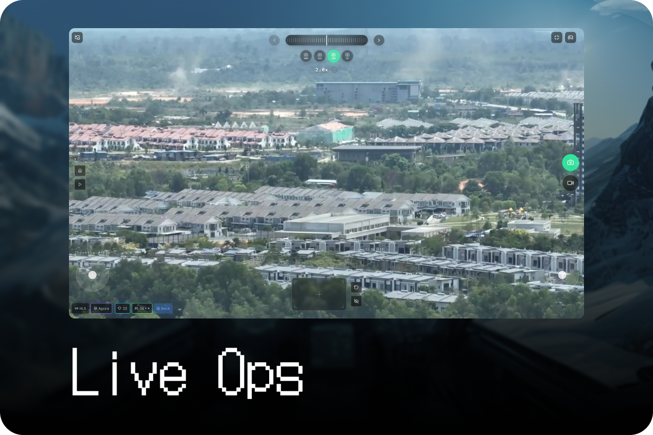
- Users can navigate with on-screen joysticks
- Pan, tilt, zoom functions via virtual trackpads
June 24th, 2025
Customisable widgets
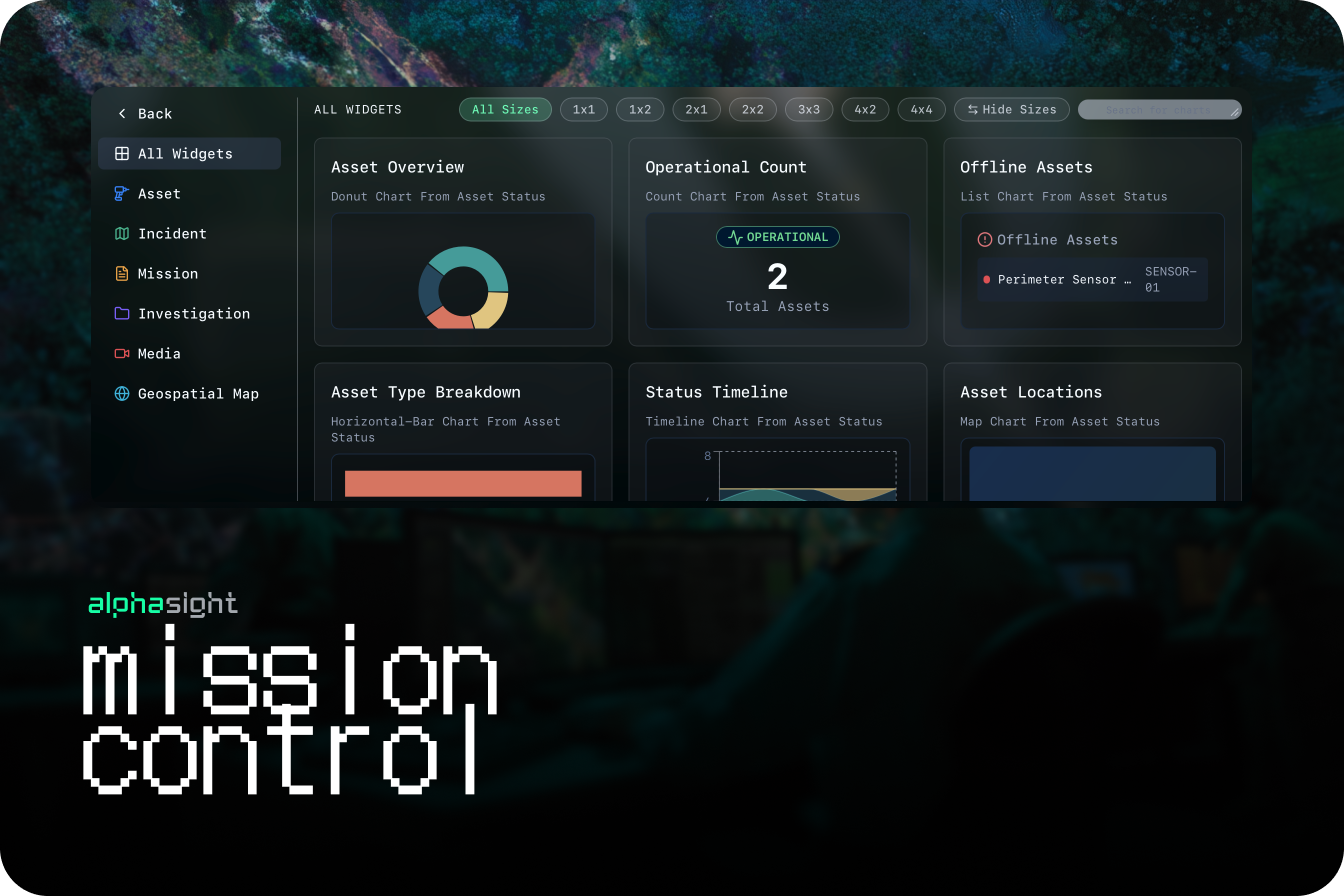
- Introduced support for multi-stream content
- Feature matching with charts
- Video Detection Pipeline: Development started on real-time object detection and classification within live video streams
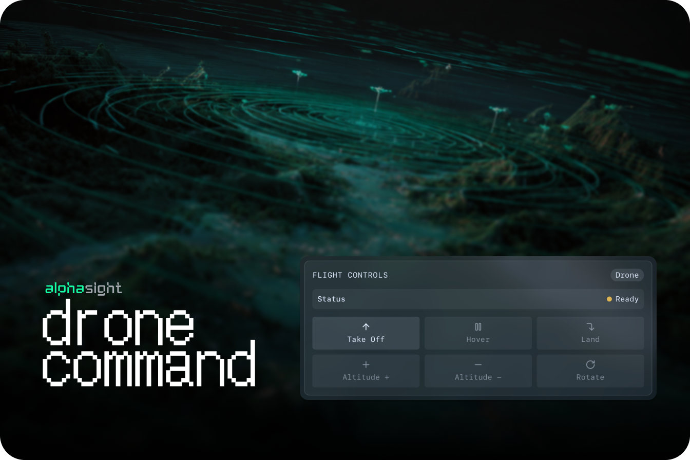
- Live Command Foundational Capabilities: Operators to take manual control or override automated drone actions during a live mission via virtual controllers
- UI Component Library Update: Refreshed UI elements to support the new widget system and improve overall visual consistency
June 9th, 2025
Custom tags

- Creation of colllections: A group of tags that can be associated with areas of interest
- Tags on Images: Make edits to images for model training scale up
- Filter Large Scale Images: Simplify the list of items on the GIS layer
- iPad and Mobile Web Responsiveness: The platform interface is now fully optimized for use on iPads and other mobile web browsers, ensuring a consistent user experience on the go.
- Base Filtering for Labels: Added the ability to filter and search for custom labels specific to the Base you are currently working in.
- Improved Touchscreen Interactions: Refined drag-and-drop and map navigation controls for better performance on touch-based devices.
May 26th, 2025
Scene Reconstruction
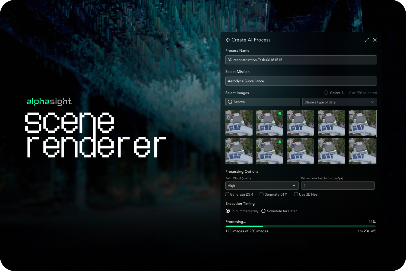
2D Orthophoto
Users can now process drone imagery to generate high-resolution 2D orthomosaic maps directly within the platform.- Supports up to 300 images per session
- Automated tiling service for web-based rendering directly on the map layer
3D Point Clouds
- Capabilities to render detailed 3D point clouds from uploaded image sets for advanced analysis and visualization
- Processing job queue & notifications: User-facing queue to track the status of reconstruction jobs and receive notifications upon completion
May 12th, 2025
Feature flagging
- Introduced a modular system to enable or disable features based on user subscription plans, roles, or for canary releases with pilot users
- Administrative UI for managing feature access
- Improvements to live telemetry data sync for multiple simultaneous operations
- Added functionality to access and remotely debug DJI drone systems through the platform, speeding up troubleshooting
April 28th, 2025
Multi-Drone Operations Command & Control
- Video streams
- Map-based pins for live drone locations
- Remote control of automated dock systems, including mission initiation and monitoring.
- KML Data Imports: Functionality to designate project data as independent data layers on the map
- Optimised web stream protocol: Significantly reduced latency on live video feeds for improved real-time command and control during critical operations
- Hardware Support Matrix: Expanded tested and validated support for the M300 RTK with H20T payload, ensuring reliable data ingress
April 7th, 2025
Geofencing
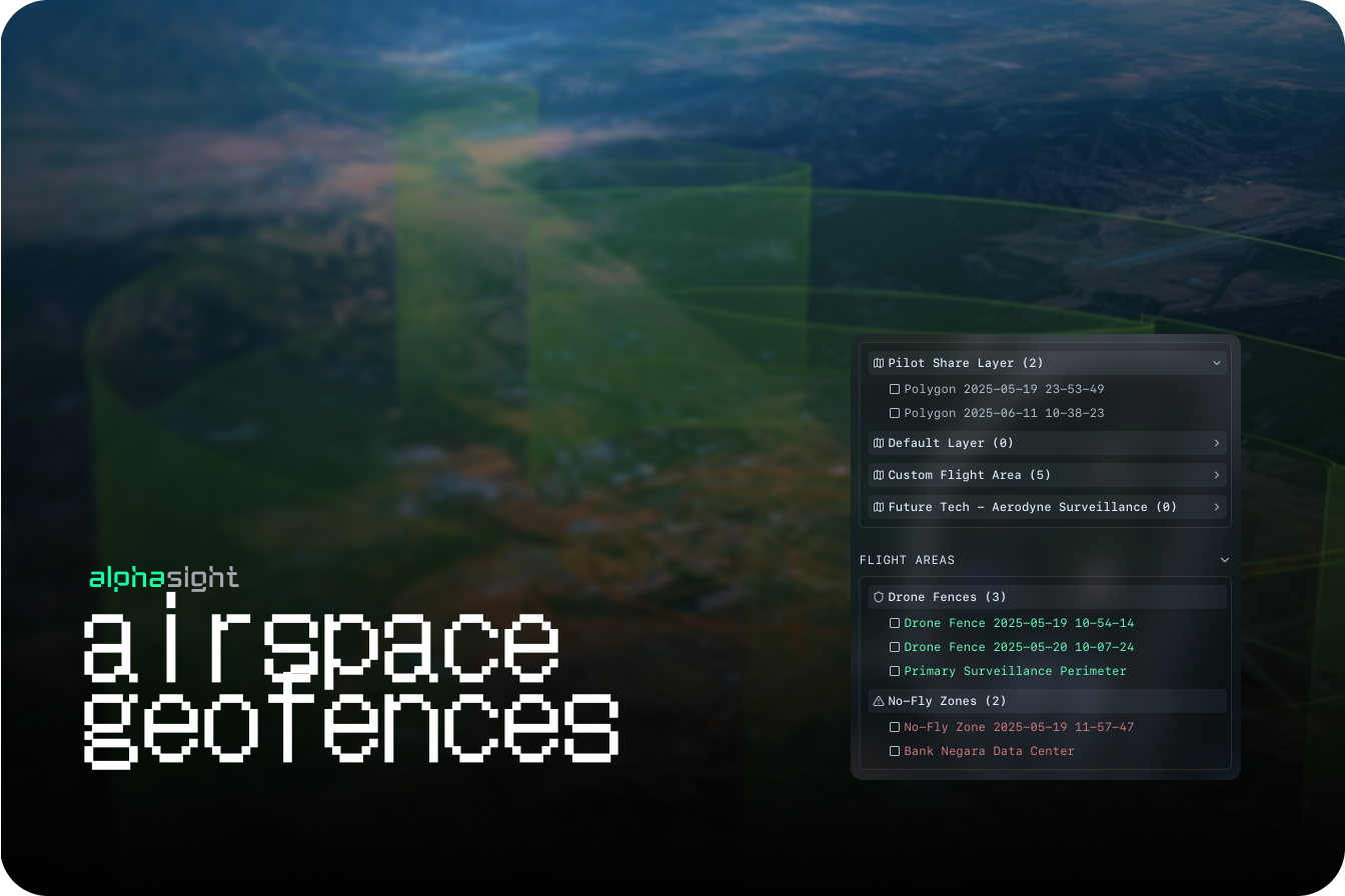
- 3rd party APIs for airspace data layers: Integrated third-party data sources to provide up-to-date information on controlled and restricted airspace
- User-defined
restrictedandfly-zonesmap based polygons
- Map rendering performance: Optimized map tile loading when multiple complex polygon layers (geofences) are active
March 17th, 2025
Team Management

- Role assignments
- Training hours
Asset & Fleet Management
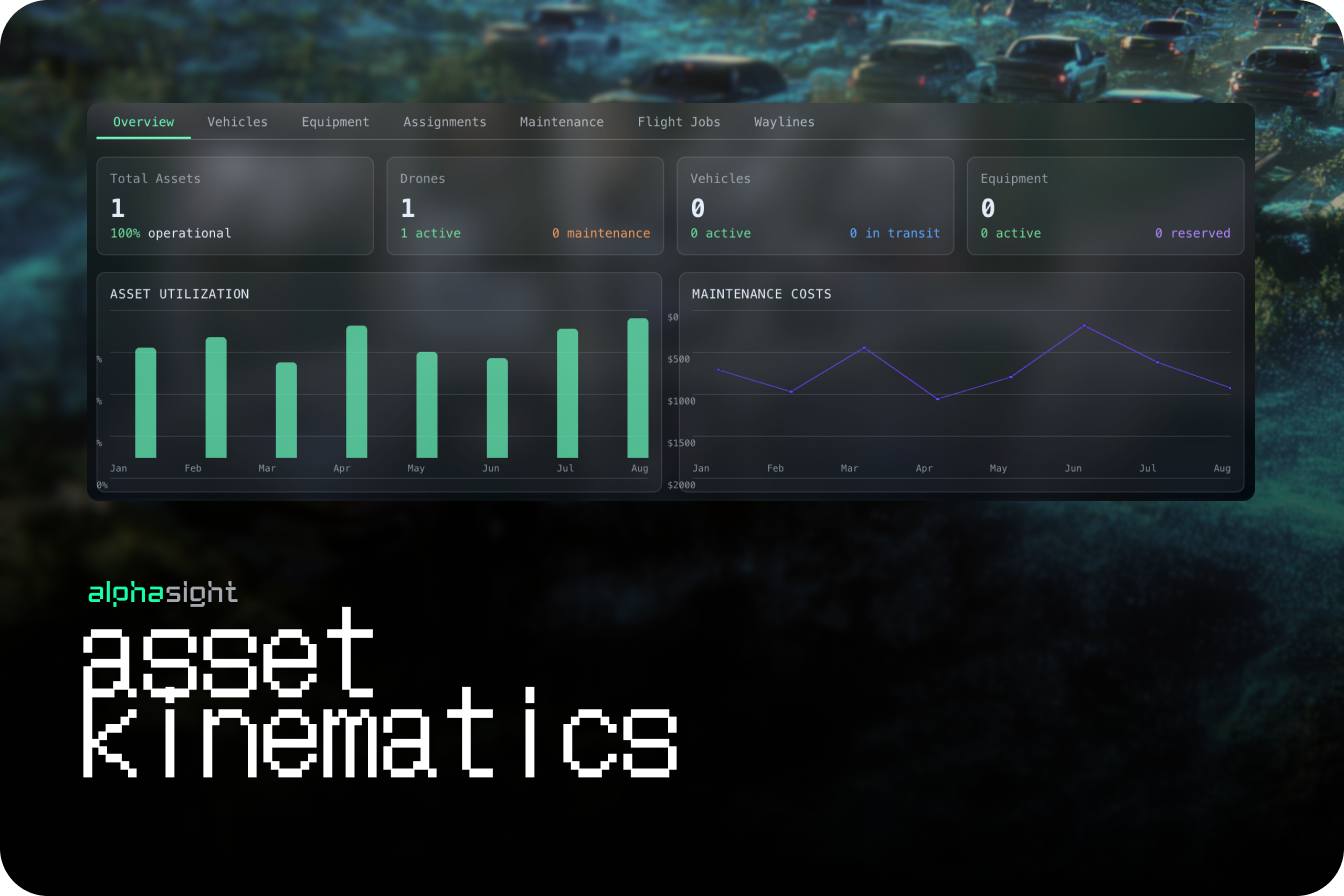
- Image viewer panels are no longer fixed and can be moved, resized, or stacked, allowing for more flexible data comparison
- User profiles now include fields for logging certifications and total flight hours
March 3rd, 2025
Object Detections
Implemented a foundational AI model for generic object classification on all incoming image data, automating the initial tagging process.- Semantic Search Capability: Users can now use natural language to search for data. For example, a search for “vehicle” will intelligently return results for cars, boats, and trucks
- Contextual AI-Based Filtering: Search filters are now enhanced to include AI-detected classifications, allowing users to rapidly sift through massive datasets.
- General UX Refinements: Introduced more interactive visual elements, improved button states, and refined layout flows for a more intuitive user experience
February 10th, 2025
Sensor-aware Projections
- Interactive Geospatial Image Projections: Images are now projected onto the map view, allowing users to click a location to see the corresponding image and its metadata
- Manual Object Tagging: Users can now manually draw bounding boxes on images and apply tags to classify objects, events, or points of interest
- Basic Search & Filter by Tag: Implemented a search functionality allowing users to filter the dataset based on their manually created tags and classifications
- Image Metadata Display: The image viewer now clearly displays all key EXIF data, including GPS coordinates, timestamp, and camera settings
January 20th, 2025
Introduction to Bases
- Multi-Tenant Workspaces (Bases): Introduced the core concept of ‘Bases’ to segment data, projects, and users, enabling secure, multi-tenant use of the platform
- New: Temporal Timeline View: Datasets are now automatically organized and visualized on a timeline, providing a clear view of data distribution over time
- Data Clustering Algorithm: Improved the logic for how datasets are clustered on the map and timeline for more intuitive grouping
- Base Creation & Management UI: Built the initial interface for creating, naming, and switching between different Bases
January 6th, 2025
Core GIS Engine
- Drag-and-Drop Data Import: The foundational feature allowing users to easily drag and drop image and data files directly into the platform for ingestion
- Initial Data Processing Core: Established the backend service for handling initial data uploads, extracting basic metadata, and storing files
- Geospatial Data Visualization: Datasets with location data are now automatically clustered and displayed as points on a world map
- File Type Support: Initial support for common image formats (JPG, PNG) and associated metadata files